Apache Pass: Vital Communication Link Between East and West
by H. G. "Bea" Hyve
Reprinted from "INSULATORS - Crown Jewels of the Wire", October 1980, page 23
What do
the words "Apache Pass" mean to you? Probably not very much. To many
people, it is some obscure geographical location, mentioned in countless western
movies and novels. But are you aware that Apache Pass is a very real place? Did
you know that over 100 years ago it played a major role in the story of
communication in the Southwest? Yes, it is true that although the Pass lies
quiet and serene today, it was once the scene of much activity, and was a vital
communication link between East and West. And only after control of this
strategic mountain pass was wrested from the Indian and came under the
domination of the white man did regular, safe, and effective communication
develop between the extensive territory we know today as California, Arizona,
New Mexico and Texas.
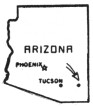
Apache Pass is located in southeastern Arizona. The
Chiricahua Mountains and the Dos Cabezas range come together seem to overlap at
their bases, and the resulting narrow defile between them is Apache Pass. Zane
Grey once described it as a "tortuous crack in the hills, dark and yellow,
almost haunted." The scenery is wild and picturesque. Great spurs and
shoulders of yellowish rock jut out from above, with a variety of shrubs and
cacti growing in tangled profusion in the eroded surfaces and gaping crevices.
The Pass has a stark beauty all it's own, found nowhere else on earth. It has
been described as having "a majestic aloofness".
Although the peaks surrounding
the Pass are two to three thousand feet higher, Apache Pass itself is as high in
elevation as many mountains. The summit at the west entrance is 5,115 feet above
sea level. Traveling eastward through the Pass the road descends 515 feet to the
east entrance, a distance of about three miles. And it is this three-mile area
with which we shall concern ourselves in this story -- for it is here that most of
the history took place which, for a time, had monumental import an the
development of communication between East and West.
But how and why did
this seemingly insignificant mountain pass in a remote corner of the Southwest
become such an important communication link? For several reasons. First of all,
through its shadowy gorges lay one of the few feasible routes through the
Southwest to California. And despite the dangers which included a grade that was
steep and tortuous, it was the shortest route from the Rio Grande to Tucson. But
most important of all, Apache Spring, located near the east entrance, was the
only water for miles around. Travelers from the earliest times were compelled to
come through Apache Pass because of the life-giving water in the permanent
springs there. To go around could mean suffering from thirst for man and animal
alike.
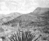
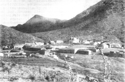
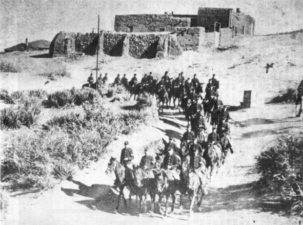
View of Apache Pass near Fort Bowie
The earliest written records of the Apache Pass region indicate the area
was in the sole possession of the Apache Indians. They had their own
communication system consisting of smoke signals and Indian message runners.
They communicated in this way for hundreds of years. Whole ideas could be
transmitted by the smoke signals, such messages being understood surprisingly
well by the other party. Apache runners could travel up to 75 miles in one day,
and the Southwest was laced with a very efficient and dependable communication
system. Other methods were also used to communicate ideas, such as marking
trees, tying knots in the filaments of the yucca, placing stones on the ground
in a certain way, or laying a piece of buckskin over a branch of a tree or
cactus -- these and many other means were used by the Apache to convey a thought
or message to others.
In 1821 the Santa Fe Trail was opened, which soon brought
an increase of white travelers into the Southwest, many of whom traveled through
Apache Pass. At first the Apaches were friendly. There were a few incidents,
perpetrated by whites, but for the most part things went smoothly. The
California Gold Rush of 1849 brought even more white adventurers into the
region. Then came the Gadsden Purchase of 1854, which gave all of modern Arizona
south of the Gila River to the Territory of New Mexico. This placed Apache Pass
into the hands of the Americans and removed it from the Mexicans, and the area
saw an even greater increase in American travelers. Even through all of this,
the Indians usually allowed the settlers to travel through Apache Pass
unmolested, showing only curiosity for the strange people with pale skin and
"white (lighter-colored) eyes".
In 1857 a contract was signed by James
E. Birch for an overland mail route, and it ran through Apache Pass. This route
was also used by the San Antonio and San Diego Mail Line, and the company
boasted that the trip could be made in only 38 days. Mail was carried by
muleback over the western segment of the route, so the line acquired the name
"Jackass Mail". The schedule called for two trips each way monthly.
Not only was this the first overland mail service between San Diego and San
Antonio, but it was the first to the Pacific Coast. Mail from San Francisco and
way points came to San Diego to start the eastward trip.
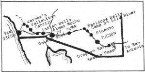
Route of the "Jackass mail" from San Diego east in 1857.
One man who
figured prominently in the development and continuation of this important
communication system in the Southwest was Silas P. St. John. A man of integrity,
courage, and vision, St. John was instrumental in building and overseeing the
construction of most of the San Antonio and San Diego Mail Line route. He was
also one of San Diego's first carriers of the Jackass Mail. The "Harbor of
the Sun" received its first mail delivery from San Antonio on August 31,
1857. On September 15 the first eastbound mail had a noisy send-off from San
Diego. A rider left at noon with his saddle bags filled. St. John took the next
leg of the journey from Carriso at 8:00 PM, and rode without a remount to Ft.
Yuma, a distance of 160 miles, in 32 hours. His route included the treacherous
Viejas and Mt. Springs grades, over 100 miles of desert, and almost 10 miles of
sand dunes. (Today I-8 follows almost exactly the route taken by St. John on
that hot September day, and takes just 3 hours in the air-conditioned comfort of
an automobile).
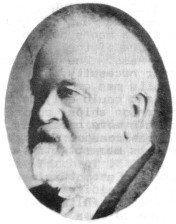
Silas P. St. John
(Title Insurance & Trust Co.
Historical Collection)
The following year, in September of 1858, the Butterfield
Overland Mail was subsidized by the government to carry U.S. Mail from St. Louis
to San Francisco. Mail was initially carried by mule and horseback until some
months later, when stations were established and stock was strung along the
line. At this time the era of coaches pulled by either mules or horses began.
The Butterfield Overland Mail route also traversed Apache Pass. The schedule
called for the run to be made in 25 days one way. Passenger fare was $200.
It
was also in September of 1858 that St. John was overseeing the finishing of the
roof of the stage station at Dragoon Springs (Arizona). Late one night he was
viciously attacked along with three other Americans by Mexican workers and left
for dead. They were assaulted with axes and knives. His three co-workers died,
but St. John survived, although severely wounded. He eventually lost an arm from
the injuries he suffered. St. John spent most of his life in express service and
in Indian affairs. He retired in 1913 at the age of 78, making his home in San
Diego. He died on September 15, 1919, at the age of 84. His home, located in the
Kensington area of San Diego, still stands. St. John was a true pioneer in the
field of early communication by mail.
Now that the overland mail road was
in service, emigrants to the West now had well-defined roads to follow. The fact
that there was plenty of fresh water in Apache Pass also became well known.
Travelers through the Pass grew more numerous with each passing month. More
confrontations between Apaches and white men took place, and as would naturally
follow, more misunderstandings. The lid was rattling furiously on the boiling
kettle of red and white relations in the Southwest. And it was in Apache Pass
that the lid finally blew off. And when it did, the fragile thread of
communication that owed much of its life to Apache Pass, was broken.
It was in
February 1861 that a series of unfortunate misunderstandings occurred between
the Chiricahua Apaches under their leader, Cochise, and the military. Cochise
and his people lived in and around the Apache Pass area, and had been at peace
with the Americans, allowing mail and travelers through the Pass. They even had
been supplying the mail station in the Pass with firewood.
But a young Army
lieutenant, inexperienced in Indian affairs, accused Cochise and his band of
kidnapping and robbery. The accusations were later proven false. But the
lieutenant's actions instigated a series of clashes which escalated into a
full-scale, bloody war between the two races -- a war that was to last 25 years.
But what is most important to our story is, that it was during this 25 year
period that the communication system in Apache Pass changed from Indian control
and came under the white man's control.
When this conflict began, naturally one
of the first areas to be adversely affected was Apache Pass. The need for water
made travel through the Pass a near necessity, but with Cochise on the warpath,
very few white men came through alive. Communication between East and West could
only be maintained by sending mail around the Horn on ships, coming across the
Isthmus of Panama, or by using a more northerly land route and having it come
down the west coast. But these methods took a long time and the news was
outdated by the time it reached California.
With the start of the Civil War in
the East, this area needing protection badly was left devoid of soldiers. It was
a grim situation. The citizens of Arizona felt deserted by the government, and
the Southwest was held in a vise-grip of Apache terror. It is to his credit as a
leader and a man, that from the time he went on the warpath until he made peace,
Cochise virtually brought to a halt all communication and travel not only
through Apache Pass, but in the entire surrounding area, thereby paralyzing,
communication-wise, the whole Southwest.
In June and July of 1862 several
battles took place in the Pass between Cochise and the military. These
conflicts, which included the famous Battle of Apache Pass on July 15, 1862,
made it all the more obvious that a need existed for troops to be placed in this
"most formidable of gorges". Because of these experiences, and in
order to protect the mail, construction was started on July 28, 1862, on Fort
Bowie, and two weeks later it was finished. Now for the first time in history
the white man was in full command of the spring and the route through Apache
Pass. Fort Bowie was to prove an invaluable asset; the key outpost from which
all future Apache Indian campaigns would be waged over the next 24 years.
Fort
Bowie-1886
Arrow and dot (right center) mark telegraph office
(Arizona
Historical Society)
Communication was reopened for a time. Supply trains passed
through safely, but the postmaster general was reluctant to resume government
mail service via this route. So in March of 1863 it was decided to establish
semi-monthly communication by a vedette system between Tucson and New Mexico.
This system of five stations had to last for three more years, during which time
the Territory of Arizona did not have a regular mail line, government or
military. But at least with the vedette stations, these five military points
could maintain contact with each other.
In December of 1866 a post office
was established in Apache Pass, but mail carriers were still being murdered by
Apaches. Their superior knowledge of the country plus their ability to strike
and disappear quickly made them almost impossible to apprehend.
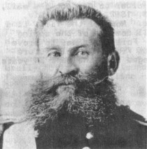
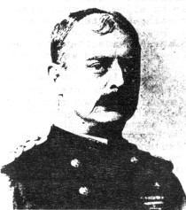
General George Crook
(Arizona Historical Society)
The war with the
Apaches was still raging when Lt. Col. George Crook of the 23rd Infantry arrived
in Tucson in June of 1871 to assume command of the Dept. of Arizona. A quiet,
mild-mannered man, Crook was honest and fair in all of his dealings with the
Indians. He was admired and respected by his men, of whom he would never ask
more than he himself was willing to give.
When Crook arrived in Arizona, the
only means of communication anywhere in the Southwest was by mail, transported
by government mail riders or stage coach. But the fierce Apaches had virtually
stopped the mail, except in the vicinity of Apache Pass and Fort Bowie, and
communication in the southern portion of the country between East and West was
almost at a complete standstill.
The idea of a telegraph line through the
territory tied been suggested as early as 1865 by the governor of Arizona,
Richard C. McCormick. (The first private line had been strung in 1865). Crook
also soon recognized a desperate need for organized communication in the area,
so that his forces could close in on the Apaches and subdue them.
In his first
Annual Report (1871) page 78, we read the following statements "Owing to
the isolated condition of this department, and the scattered distribution of its
[military] posts, the construction of a telegraph-line from California to this
country, with branches to some of the important posts, would not only be of
great service, but would be economy to the Government." It was believed
that government aid should be given to some telegraphic company for the
extension of lines to important points in the Territory. So, with the support of
such important men as the commanding general of the Army, William T. Sherman,
the plan for a telegraph system through the Southwest moved slowly ahead.
It was felt that the best connecting point on the western end of the line would
be San Diego. This city was connected to an already-operating telegraph system,
having received telegraphic communication with Los Angeles to the north in
August of 1870. Western Union agreed to build the line, headed by a veteran in
telegraph construction, James Gamble. He said he would build the line at cost,
and the Army could deduct its labor and transportation expenses from the total
cost. The details of construction were outlined, and the route was decided upon,
with San Diego as the western terminus. The line would pass east through Yuma,
Maricopa Wells, and a branch line from there to Tucson. The main line would go
to Prescott. Total distance, following wagon roads as the route from San Diego
to Tucson -- 628 miles.
Across the barren area from San Diego to Yuma would be
placed willow poles, 17 to the mile instead of 20 due to the absence of snow
along that portion of the route. They were tarred at the bottom to increase
longevity.
Cottonwood poles would be used for the route east 75 miles from Ft.
Yuma. They would cost one dollar each and be placed 20 posts to the mile. Wire
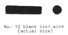
for the line would cost $30 per mile for No. 10 annealed black iron wire. Glass
insulators, $.25 each. Instruments and batteries from San Francisco would cost
about $120 for each station. Tools for the workers and incidentals added up to
about $52.95 per mile. With added expenses (payroll, etc.), the cost per mile
was $79.35. Total estimated cost, $50,311.80. Although Western Union was to
build the line, the military would operate it for reasons of economy for the
government.
Arizonans were strong in their feelings that the government should
aid in the building of the telegraph. They felt that this would help make up for
the government's running off to fight the Civil War and leaving them to the
questionable mercies of the Apaches. The bill containing the proposal and budget
for the project went to Washington, and McCormick, the governor, went with it.
After much talk and promoting, the bill became law on March 3, 1873, and the
money was appropriated.
On June 4, 1873, a Western Union employee named R. R.
Haines was hired as Superintendent of Construction. The equipment and material
began to be gathered for the new line by the Quartermaster Corps in San
Francisco. Contracts with civilian companies were made for the equipment.
Telegraph instruments, tools, insulators, and wire were purchased from the
Electrical Construction and Maintenance Company (E.C. & M. Co.) of San
Francisco. This company in turn subcontracted for the wire from the Pacific Wire
Manufacturing Company, also of that city. Both civilian and military overseers
were appointed for the various departments.
Forty tons of wire was delivered by
boat to Port Isabel (in the Gulf of California below Yuma), and then transferred
to a barge which was pulled upriver to Yuma by steamer. (In the days before
irrigation of the Imperial Valley and the building of flood-control dams, the
Colorado River at Yuma and below was much wider and deeper than it is today,
making it navigable by large vessels). Insulators, wire, and other construction
material for the route eastward from Yuma was hauled to the construction sites
by mule pack trains; the poles by wagon. Material for the western portion of the
line, from San Diego to Yuma, was delivered by boat to National City,
California, just a few miles south of San Diego.
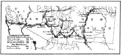
Route of the military
telegraph system
throughout the Southwest (c. 1876)
(Arizona Historical Society)
The first pole was set in the ground at San Diego on August 28, 1873, and at
Prescott on September 2. The following November 11, Prescott was joined with
Yuma. Yuma and San Diego were joined by wire on November 18, and many
congratulations were passed over the wire between Prescott and San Diego. At
last Arizona was joined communication-wise to the "outside world"! By
December Tucson was hooked up to the system. It remained now to link Tucson and
New Mexico via Fort Bowie in Apache Pass, thus completing the telegraph system
throughout the Southwest.
In 97 days there had been 540 miles of telegraph line
built, 9,820 poles set, at a cost of $47,557,97. (over $2,700.00 under the
estimated cost). It was the most important work ever undertaken in Arizona up to
that time, considerable even more so when one realizes that most of the terrain
covered included bottomless canyons, dizzying crags, snow-covered sierras, vast
deserts; an unbelievable array of all the contradictions possible in topography.
By 1874 Congress appropriated more money to extend the telegraph system to other
parts of Arizona. And on March 3, 1875, it passed a new telegraph bill covering
construction of a line connecting Santa Fe, New Mexico, with Tucson, passing
through Fort Bowie. Army troops were used to provide the labor. This was
possibly the most important link in the telegraph system along the Southwestern
border, for it included the notorious Apache Pass.
Second Lieutenant
Philip Reade was put in charge of the new line between New Mexico and Arizona in
June of 1875. He advertised in a Tucson newspaper for the purchase of poles,
asking for them to be delivered along the route, which paralleled a good wagon
road. Poles were to be of pine, oak, or cedar, 22 feet long, and not less than
eight inches in diameter at the bottom, with the bark well peeled. Not acceptable were poles of cottonwood, willow, aspen, or poplar. Poles were to be set in
the ground 3-1/2 to 4 feet deep, depending on soil conditions. Distance
between poles was to be 70 yards and 1 foot, or 25 to the mile. He then
described the method of placing the insulators on the poles and the stringing of
the wire. From the Arizona Citizen, December 4, 1875, we read:
"Insulators should be seated firmly by cutting a flat seat on the side of
the pole, and nails driven home. The top of the insulator should not project
above the top of the pole, but be flush with it. Wire should be on the same side
of all the poles. At an angle in the line the insulator must be placed on the
inside of the angle in order that the strain shall be toward the pole, and at
such angle the wire may be changed from one side of the poles to the other if
desirable; but lengths between angles must be on the same side of all the
poles." Reade went on to describe how to make the connections in the wire,
the placement of lightning rods, and the placement of supplies along the route.
He left little to the imagination, and it was clear he intended to build a
telegraph line that would endure.

Large Image (119 Kb)
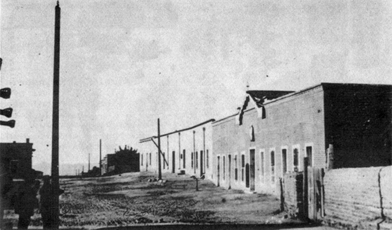
The military telegraph line through Tucson
looking north at Court and Library Streets (c. 1880's)
(Bushman Collection - Arizona Historical Society)
The record is silent as to what type of
insulators were used on this portion of the line. However, complaints were later
submitted stating that the brackets for the insulators were inferior, and that
the wood screws provided with the brackets for connection to the insulators were
too small. And so were the nail holes in the bracket for attachment to the
poles. Twelve incomplete glass insulators have been found at Fort Bowie so far,
and they fall into three types.
Large Image (300 Kb)
The military telegraph line through Fort
Bowie (c. 1880's)
(National Park Service)
Six are pony insulators, CD
102. Three of these ponies are embossed with the patent dates Jan. 25, 1870 and
Jan. 14, 1879. One threadless signal-type insulator fragment was recovered,
which is probably a CD 728 or 733, and is unembossed. The last five are CD
126's. Three of these five are Brookfields. Two bear the patent dates mentioned
above, as well as 45 Cliff St., NY. The third Brookfield insulator of this type
apparently has a patent date of March 20, 1877.
By February 1876 funds ran out,
so Reade began asking citizens to provide poles. Dwellers from the key cities
and farmers living in the area donated poles and offered to haul them to the
construction sites free of charge. By April construction was resumed. By the
first week in May, 1877, that portion of the line from Santa Fe to Tucson
through Fort Bowie in Apache Pass was completed, and Arizona was now linked both
east and west by telegraphic communication. And as Crook had foreseen, the
telegraph was to help in subjugating the renegade Indian bands that ravaged the
Southwest.
Brigadier General Philip Reade
(In later years)
(National Archives)
But what did the Indians think of the telegraph? Although the
Apaches probably understood the system, they were not much different from other
tribes in other areas, who had demonstrated a superstitious respect for it. The
Apaches named the "white man's talking wire" Pesh-bi-yalti. And when
they chose, they could be very clever at disrupting the service. Among their
many tricks was cutting the wire and tying the ends together with a buck- skin
thong, making it difficult for repair crews to find the break. But for the most
part, the Indians kept their distance from Pesh-bi-yalti.
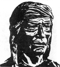
Cochise, Chiricahua Apache
chief
The great chief Cochise had made peace with the Americans in 1872.
(Cochise never allowed himself to be photographed. However, he may have looked
very much like the above drawing which was made from a bust of him, which is on
display at the Cochise Visitor Center, Willcox, Arizona). The story of
brotherhood and friendship which took place between Cochise and Tom Jeffords is
a story often told. But for the sake of our dissertation, it bears repeating.
Tom Jeffords was working as superintendent of the mails in Tucson in the middle
1860's. After losing 14 of his mail riders to the Apaches in Cochise's
territory, he decided to try and meet with the chief and ask him to allow his
mail riders to go through unmolested. Their meeting resulted in a deep
friendship between the two men that was to last until the death of Cochise. And
it was through Jeffords that President Grant's peace emissary, General Oliver 0.
Howard was able to meet with Cochise and make peace. Cochise lived only two
years after the peace, and died on June 8, 1874. He was succeeded by his son,
Taza. Although he had good intentions, Taza did not exhibit the leadership
qualities and strong personality of his father. Two years after the death of
Cochise the era of the Geronimo wars was ushered in.
Geronimo, also a Chiricahua
Apache, was a medicine man and war leader -- never a chief. Bored and restless
with the restrictions of reservation life, he and several other warriors,
including Naiche, younger son of Cochise, left the reservation for Mexico. The
year was 1876, and thus began another Apache war which was to continue for ten
more years.
By 1880 the Southern Pacific Railroad rails were laid through Bowie
Station (present day Bowie), bypassing Apache Pass and Fort Bowie by about 13
miles to the north. This spelled the end of the military telegraph in Arizona.
By 1882 the line to Fort Bowie from Fort Apache was one of very few stations
still operating in Arizona. The military telegraph was abandoned between San
Diego and Yuma also by 1882, and was replaced by the civilian (privately-owned) telegraph.
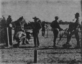
Setting up a heliograph in Arizona
(c. 1880's)
(Arizona Historical
society)
As the Geronimo campaign raged on into the mid 1880's, it soon
became apparent that a more mobile means of communication than the telegraph was
needed. An instrument was necessary that was compact enough to be packed on the
back of a mule, simple enough so that it could be set up anywhere at a moment's
notice, and yet provide instant communication. The answer was found in a simple
combination of sunlight, mirrors, and Morse code, called the heliograph, or
heliostat.
With the coming of the rails and the abandonment of the military
telegraph, the heliograph came into extensive usage. The "field"
heliograph consisted of an adjustable mirror mounted on a tripod. The heliograph
stations were usually situated on mountain tops, and operated by a team of
signal corpsmen, a sergeant and three privates. Messages called
"heliograms" were flashed from some 27 stations across the sunny skies
of New Mexico and southeastern Arizona. The mountains in Apache Pass contributed
to the importance of Fort Bowie as an important heliograph station. In fact, the
station on Bowie Peak (above Fort Bowie to the south) was the hub of all the
stations in Arizona -- here more messages were sent, received, and repeated than
at any of the other stations in the system.
The average distance between
stations was about 25 miles, although sometimes the mirror flashes could be read
as far as 50 miles away. The heliograph was introduced into the Southwestern
Indian wars by General Nelson A. Miles in May, 1886. (Miles had replaced General
George Crook as commander of the Dept. of Arizona earlier that year). These
"talking mirrors", the Army's equivalent of the Indian smoke signals,
were instrumental in helping the military to close in on Geronimo and his band.
When he surrendered to Miles through the efforts of Lt. Charles B. Gatewood in
September of 1886, the heliograph system was discontinued. Arizona was at last
free from Indian depredations.
A telephone line between Fort Bowie and Willcox
(27 miles west) was established in 1890. It replaced the telegraph as the post's
only means of rapid communication with the outside world. And in October of
1894, just before the fort was abandoned, Lt. P. 0. Lockridge and a detachment
from the post tore down the telegraph line between Fort Bowie and Willcox.
Fort
Bowie was abandoned by the Army in 1894, having seen 32 years of continuous
service as the guardian of Apache Pass. Says Richard Murray in his "History
of Fort Bowie", "Of all the posts set up ... which were involved in
the Apache struggle until the end, none served a more important purpose, nor was
more strategically located, nor had a more colorful history than Fort
Bowie."
Arizona was admitted to the Union in 1912. Roads began to be built
all throughout Arizona. About this time a graded road was constructed through
Apache Pass, following closely and generally (north of the old Butterfield Trail
blazed in the 1850's. The old trail is still visible in some places in the
Pass). The graded road is still used, although the main highway, I-10, follows
alongside the Southern Pacific tracks and passes 13 miles to the north of Apache
Pass.
In 1964 Congress authorized the making of Fort Bowie a National
Historical Site, and formal establishment took place on July 29, 1972. One can
visit the ruins of Fort Bowie by taking the Apache Pass Road south out of Bowie.
A pleasant hike of about a mile and a half will bring you to the site of the
fort.
Apache Pass -- a place of rugged beauty, mystery, and enchantment. It lies
peaceful now under the bright Arizona sun, its wild and haunting scenery hearing
only the soughing of the wind and the occasional hum of an automobile as it
threads its way over the dirt road. As one drives through Apache Pass today, it
is hard to imagine that this three mile cut between two mountain ranges was once
such a vital link in the history of communication in the Southwest.
- - - - - - - - -
When I was
young I walked all over this country, east and west, and saw no other people
than the Apaches.
After many summers I walked again and found another race of
people had come to take it. -- Cochise.
- - - - - - - - - -
I wish to give special thanks to Mr. Bill
Hoy, Ranger-in-charge at the Fort Bowie National Historic Site, for his help
with my story. He not only answered all of my questions patiently, but provided
the photo of Fort Bowie showing the military telegraph line, and was kind enough
to read my manuscript and check the accuracy of my statements.
REFERENCE SOURCES
Arnold, Elliott, Blood Brother. (1947).
Bourke, John G., On The Border With Crook. (1891).
Goodwin, G., and Basso, K., Western Apache Raiding And Warfare.
(1971).
Grey, Zane, Fighting Caravans. (1929).
Herskovitz, Robert M., Analysis
Of Material Culture From Fort Bowie, (National Historic Society, Arizona. 1975).
Lockwood, Frank C., The Apache Indians. (1938).
Murray, Richard Y., The History
Of Fort Bowie, (Master's thesis, Univ. of Arizona. 1951).
Rue, Norman L., Words
By Iron Wires Construction Of The Military Telegraph In Arizona Territory,
1873-1877, (Unpublished thesis, Univ. of Arizona. 1967).
|

)
)
)
)
)
)
)
)
)
)
)